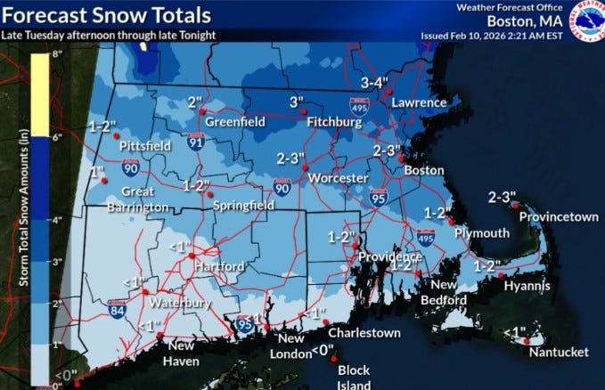
URGENT UPDATE: A fast-moving snowstorm is set to impact Rhode Island later today, bringing 1 to 2 inches of snow to the northern regions. The National Weather Service forecasts that snow will begin this afternoon and continue into the night, with the southern part of the state likely experiencing a mix of rain and minimal snowfall.
While this storm is not expected to deliver heavy snow, parts of Massachusetts and the northeastern U.S. could see accumulations of 3 to 4 inches. In Rhode Island, these new snow totals will build on an already substantial snowpack, as the state has seen over 20 inches of snow in January and an additional 2.6 inches so far in February. The Providence area currently has about 10 inches of snow remaining on the ground.
The extreme cold that has gripped the region is finally beginning to ease, with temperatures expected to rise to a high of 34 degrees Fahrenheit in Providence today. This is a welcome relief, as February has been unseasonably cold, averaging 19.9 degrees, which is 10.5 degrees below normal for this time of year.
Forecasters are closely monitoring the weather, as another potential coastal storm is on the horizon this weekend. Residents are encouraged to stay updated on the latest forecasts and prepare for changing conditions.
As the storm approaches, those in impacted areas should be cautious while traveling and stay informed through official channels. The weather service emphasizes the importance of keeping safe during winter storms and advises residents to check on vulnerable neighbors and ensure they are prepared for the cold.
Stay tuned for more updates as this developing situation unfolds.