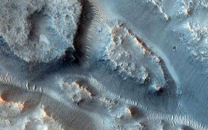
A team of scientists from the University of Texas at Austin has successfully mapped ancient river basins on Mars, providing crucial insights into the planet’s watery history. This groundbreaking study, published in the *Proceedings of the National Academy of Sciences*, outlines the identification and analysis of Martian drainage systems, shedding light on how much water existed on the Red Planet in its early days.
Utilizing data from the Mars Orbiter Laser Altimeter (MOLA) and the Context Camera (CTX), researchers set out to map drainage systems significant enough to exceed 10,000 km², a standard area for large systems on Earth. MOLA was instrumental during NASA’s Mars Global Surveyor missions from 1997 to 2006, while CTX continues to orbit Mars aboard the Mars Reconnaissance Orbiter, providing comprehensive coverage of the planet’s surface.
The study successfully identified 16 distinct drainage systems, which the researchers estimate transported approximately 28,000 km³ of sediment. This volume represents around 42 percent of the total flowing sediment volume across ancient Mars. Notably, outlet canyons alone contributed nearly 24 percent of the global river sediment on the planet.
Understanding Mars’ Hydrological History
Mars is estimated to have formed about 4.5 billion years ago, and while the scientific community debates the timeline of surface liquid water, some studies suggest it existed as recently as 2 billion years ago. The findings from this mapping study enhance our understanding of ancient Martian landscapes, which include water deposit systems, lakes, and valley networks.
In addition to the river basins identified, there are various geomorphological features that indicate the presence of past liquid water on Mars. These include deltas, outflow channels, and gullies, along with mineralogical evidence such as clays and sulfates. The presence of hematite, also known as “blueberries,” was notably confirmed by NASA’s Opportunity rover in 2004.
The study’s researchers employed ArcGIS Pro, a mapping software, to analyze Martian drainage patterns. By identifying the convergence points of these river systems, they aimed to further understand the hydrology of ancient Mars. The implications of this research extend beyond Mars; it sets a precedent for mapping ancient river systems on other celestial bodies.
Factors in Mars’ Water Loss
Scientists speculate on several reasons for the loss of liquid water on Mars, including the depletion of its magnetic field and subsequent climate collapse. Unlike Earth, Mars has a smaller core, which cooled more rapidly, leading to the dissipation of its magnetic field. This left the Martian surface vulnerable to intense solar and cosmic radiation, which likely stripped away much of its atmosphere and water.
Some water may have escaped into space, while models suggest that a portion could be buried underground, potentially stored in polar regions. This ongoing research not only enhances our understanding of Mars’ past but also raises questions about its potential to harbor life.
As researchers continue to investigate the river basins of ancient Mars, the insights gained could revolutionize our understanding of not only the Red Planet but also the history of water on other planets in our solar system. The quest for knowledge about Mars’ hydrological past is far from over, and the findings of this study pave the way for future explorations.