A collaborative study involving researchers from Fudan University, the University of Twente, and Chengdu University of Information Technology has yielded significant advancements in soil freeze-thaw detection using satellite technology. Published on September 10, 2025, in the Journal of Remote Sensing, the research introduces a dynamic parameter optimization algorithm that enhances the accuracy of monitoring soil freeze-thaw transitions from spaceborne L-band measurements.
The freeze-thaw (FT) transitions in soil play a critical role in influencing weather patterns and hydrological cycles. Traditional models often overlook the complexities of diurnal soil temperature variations and surface heterogeneity, making it challenging to capture these dynamic processes effectively. The study addresses these limitations by developing a robust parameter-optimization framework that adapts to regional land cover, terrain, and climate variations.
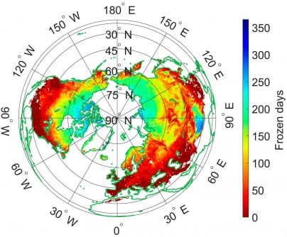
Current algorithms, particularly those based on the Soil Moisture Active Passive (SMAP) satellite, rely on fixed global parameters that may not be suitable for diverse environmental conditions. The newly developed approach improves the existing Diurnal Amplitude Variation-based Freeze-Thaw (DAV-FT) algorithm by incorporating three dynamically optimized parameters—α, β, and γ. These parameters represent the detection period, variance window, and threshold sensitivity, respectively.
Through a method similar to maximum likelihood estimation, the research team tuned these parameters to maximize overall classification accuracy (OA) across various regions. Results indicate a substantial increase in the areas where OA exceeded 0.7, rising from 54.43% to an impressive 89.36%. The algorithm demonstrated its strongest performance in the Qinghai–Tibet Plateau, southwestern Eurasia, and southern North America.
The study also validates the new model’s findings with high consistency against other datasets, achieving an accuracy of 81.28% compared to ERA5-Land data and 79.54% with SMAP-FT datasets. Validation efforts using data from 828 in situ soil temperature stations confirmed the algorithm’s enhanced accuracy and stability, yielding a median accuracy of 0.92, which surpasses both fixed-parameter and existing SMAP products.
Dr. Shaoning Lv, the corresponding author of the study, emphasized the significance of the dynamic parameter optimization. “This advancement allows us to capture subtle soil freeze-thaw transitions that vary across regions and seasons,” he stated. He added that by reflecting diurnal surface changes in real time, the method not only refines retrieval accuracy but also enhances our understanding of land-atmosphere interactions.
The improved DAV-FT algorithm stands as a powerful tool for continuous soil freeze-thaw monitoring across diverse terrains. It offers vital support for climate modeling, agricultural management, and hydrological forecasting. Its ability to account for diurnal temperature cycles and regional heterogeneity makes it particularly beneficial for high-latitude and mountainous regions, where existing algorithms often face challenges.
By refining the accuracy of soil state detection from space, this innovative method strengthens the foundation for assessing permafrost dynamics, water availability, and land-atmosphere energy fluxes—critical elements in predicting climate change impacts and enhancing global land-surface models.
The research received funding from several sources, including the National Key R&D Program of China, the Key Research and Development and Achievement Transformation Program of Inner Mongolia Autonomous Region, the Yan Liyuan–ENSKY Foundation Project of Zhuhai Fudan Innovation Research Institute, and the National Natural Science Foundation of China.